VLF Surveys
Introduction
Very Low Frequency (VLF) surveys are geophysical techniques that use radio waves in the 15–30 kHz frequency range to detect and map shallow subsurface conductors. These surveys leverage radio transmitters, often used for military or communication purposes, to create electromagnetic fields that interact with conductive materials beneath the Earth's surface. The method is particularly effective for identifying and mapping shallow structures such as mineral deposits, fault lines, shear zones and fractures.
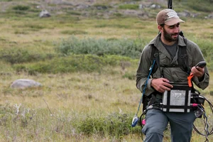
VLF surveys are highly valued in mineral exploration, environmental studies, and geophysical mapping due to their non-invasive nature and the ability to provide rapid and detailed subsurface information. The technique is widely used to delineate subsurface anomalies, define geological structures, and assess groundwater or environmental contamination. Generally, an operator in the field will perform total field magnetics and VLF surveys simultaneously.
Although VLF surveys were widely used, the data was generally limited to qualitative interpretation. Modern processing methods allow for interpretation of dip or geometry, depth and relative conductivity. datasets hold a wealth of untapped information, and advanced analysis methods can extract new insights to drive exploration success.
Survey Design
Survey line direction and station space considerations. In the ideal scenario, the survey line direction is perpendicular to geological strike and also perpendicular to the incoming signal.
Here are the 4 transmitters that are typically used for surveys

Here is an example of the incoming signal for a particular project in British Columbia, Canada.
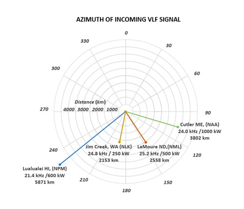
At this project site the incoming signal from the 4 transmitters span angle from 106 degrees to 231 degrees. For maximum electromagnetic coupling, a transmitter station is selected which is parallel to the geological strike or the dominant structural trend of the survey area. This way, the proposed survey lines will be perpendicular to geological strike and the incoming signal. In some cases, two or more survey line azimuths are selected with corresponding set of frequencies to be measured. Finally, if required we can install a local VLF Transmitter to act as a signal source in the event that the remote transmitters are not available or appropriate.
A logistical factor to consider in survey planning is that the VLF transmitters have regular and sometimes irregular maintenance schedules. About once a week each transmitter has down time for maintenance and is not available for use. Aurora Geosciences maintains and updates a record of the signal strength from each of these transmitters, and the archive is update once a week so that any changes in Maintenance schedule or other deviations in the reliability of the signal is known. The table above shows recent maintenance schedules. For practical purposes when a priority VLF signal is not available, the crew for collecting magnetic tie line data to improve the leveling of the magnetic survey.
Synthetic Data Examples
Now we are going to present some synthetic data sets generated from forward models, and the recovered inverse model. In these examples the background resistivity was held constant at 1000 ohm.m and the conductor at 100 ohm.m. Here are some examples using synthetic datasets:
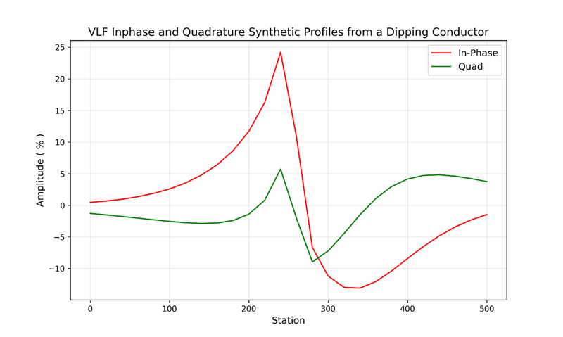
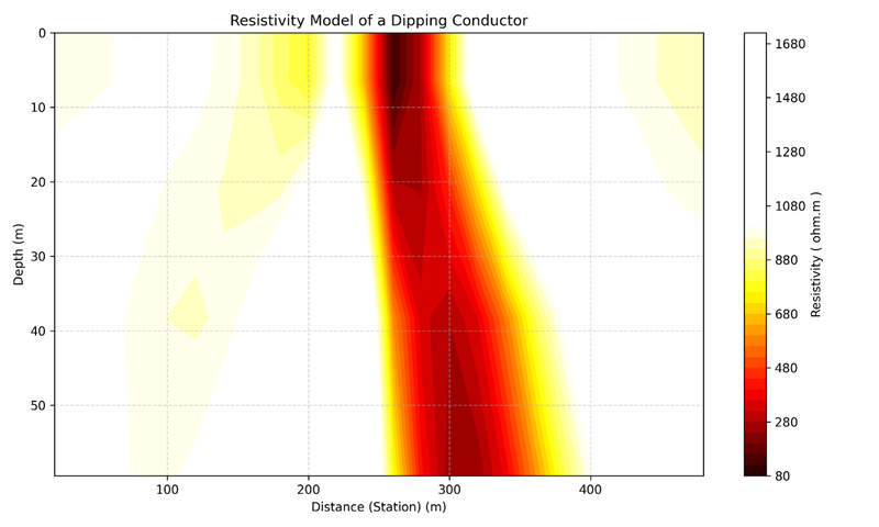
- Recovering dip angle of a conductor dipping 45 degrees to the right.
Here is the measured in-phase and quadrature profiles over a conductor dipping to the right at 45 degrees
And here is the model recovered by 2D inversion.
In the next two examples, we are going to estimate the depth to the top of a vertical conductor.
Two scenarios from a conductor at 2m depth and 50m depth
2 metre depth
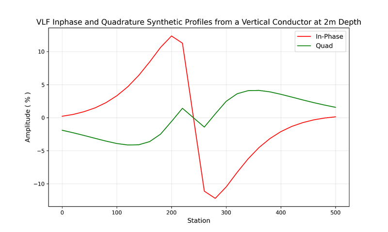
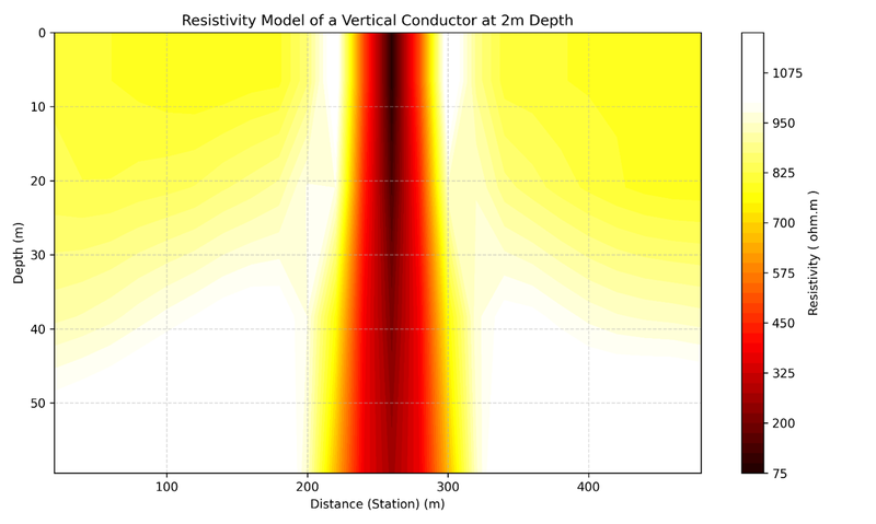
50 metre Depth
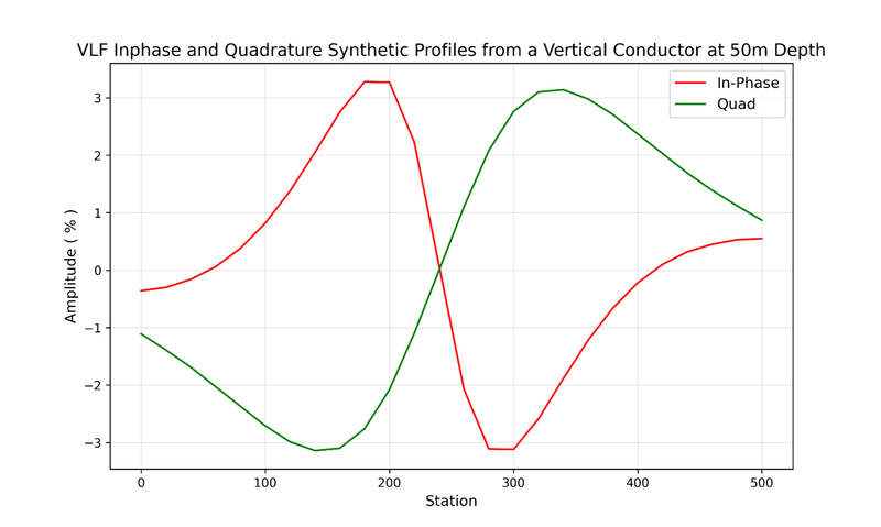
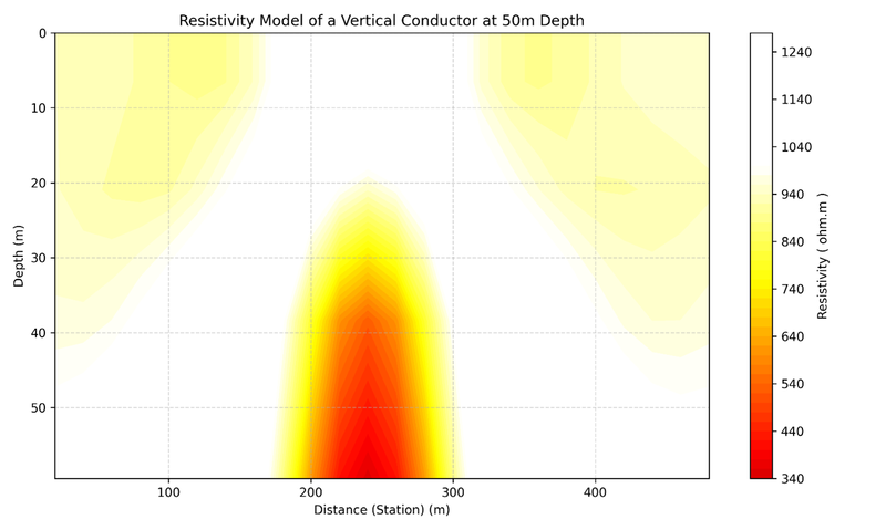
In conclusion, by leveraging modern processing techniques, we can transform historical data into 2D and 3D models, enabling further quantitative analysis. This approach not only enhances data quality but also provides more accurate insights into conductor geometry and mitigates the challenges posed by topography, enabling a refined and reliable interpretation.
Related Services
Find Us
Yellowknife
3506 McDonald Dr.
Yellowknife, NT
Canada
X1A 2H1
Whitehorse
34A Laberge Rd.
Whitehorse, YT
Canada
Y1A 5Y9
Juneau
Juneau, AK
United States
