Geophysical methods for kimberlite exploration in northern Canada
Adapted from "The Leading Edge" Volume 23, Issue 11 - Society of Exploration Geophysicists
https://doi.org/10.1190/1.1825939
MIKE POWER and GEORGES BELCOURT, Aurora Geosciences, Whitehorse, Canada
ED ROCKEL, Diamondex Resources, Vancouver, British Columbia, Canada
In 1991, the discovery of diamondiferous kimberlite in Canada's Northwest Territories (NWT) precipitated the largest mineral staking rush in North America and sparked a remarkable exploration effort which extended across northern Canada. Thirteen years later, two diamond mines with estimated annual productions of $1 billion (Can) are in operation, a third is in permitting, and several other projects are approaching development. Ekati mine, operated by BHP Billiton since 1998, produced 4.8 million carats from 4.2 million tons of ore in 2003 while the nearby Diavik diamond mine yielded 2.7 million carats from 1.0 million tons of ore during the same period. When Diavik has achieved full production in 2004, Canada will account for 15% of global diamond output by value. The exploration programs which created this new industry relied heavily upon the efficient application of complementary geophysical techniques. This paper overviews geophysical exploration methods currently used in diamond exploration in northern Canada.
Slave Craton Kimberlites.
Diamond deposits in northern Canada are hosted in kimberlite intrusions in and adjacent to the Archean Slave Craton in the NWT and Nunavut Territory (north of 60°N). Kimberlite is a volatile-rich ultra-basic igneous rock composed of macrocrysts of mantle-derived material enclosed in a matrix of olivine, clinopyroxene, micas, carbonates and serpentine. Kimberlite magmas are generated at depths in excess of 100 km and reach the surface by means of a very rapid ascent through the crust, frequently terminating in explosive eruptions. The violent stopping associated with magmatic ascent results in the inclusion of significant quantities of mantle peridotite and eclogite, commonly in centimeter-sized nodules. When diamonds are present in either the magma source region or in an area through which the magma ascends, they are incorporated into the kimberlite intrusion.
In the earth, diamond is present as a stable mineral only at depths greater than 150 km and temperatures less than 1200°C. These unusual P-T conditions are largely confined to mantle roots situated beneath stable Archean cratons. Beneath these tectonic elements, the depth of the 1200°C isotherm is deflected from 75 km to as much as 200 km, creating a diamond stability field at depths of 150-200 km. Kimberlite magmas originating within and beneath these regions can tap this material and are potentially diamon-diferous. The rapid ascent of kimberlite magma at velocities in the order of 100 km/hr, preserves diamonds entrained in the magma during transport through the upper asthenos-phere. Only about 1% of kimberlite intrusions contain diamonds in economic concentrations.
Figure 1 shows the location of most kimberlite intrusions in the NWT and Nunavut. The majority intrude granitoid and lesser supracrustal rocks of the Slave Craton but they are also found in adjacent areas where thin Proterozoic and Phanerozoic sequences overlie Archean basement rocks. Intrusion emplacement dates from a limited number of pipes in the central Slave Craton vary from Permian to Eocene but the majority of the intrusions are either Cretaceous or Eocene. As a consequence, the intrusions cut all known rock units and subcrop beneath a variable depth of glacial overburden. Emplacement is controlled by both shallow and deep-seated structures. On the whole, the kim-berlites are intruded on a NNW-trend, extending from Victoria Island to the eastern end of Great Slave Lake. Individual kimberlite clusters consisting of 3-10 pipes follow subsidiary NNE- and ENE-trends.
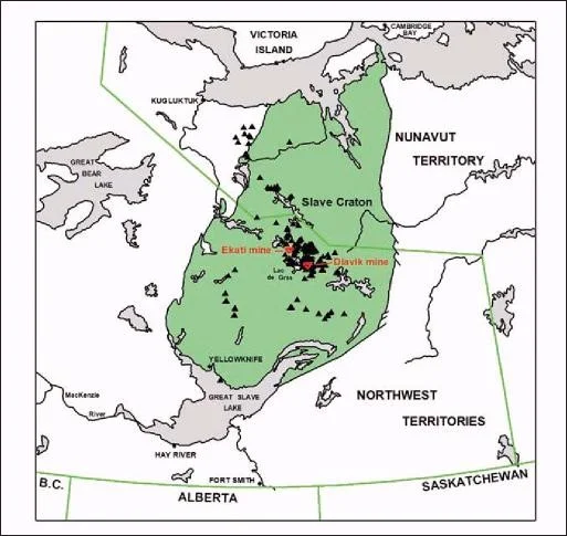
Figure 1. Principal kimberlite pipes and dykes in the NWT and Nunavut located since 1991.
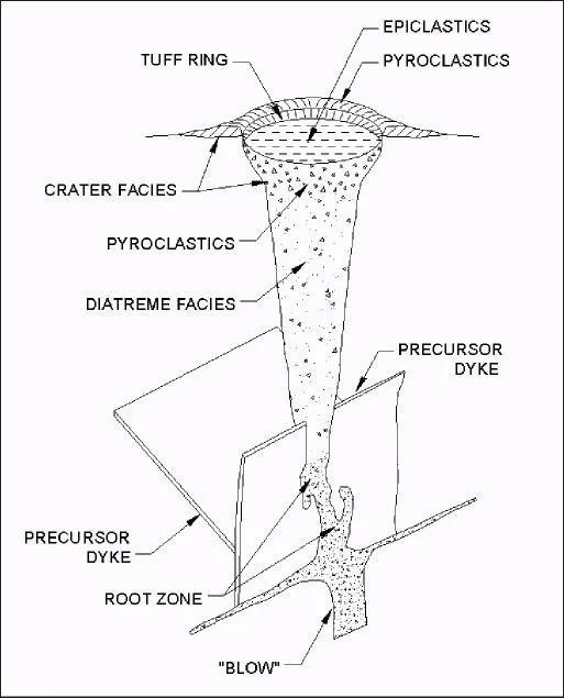
Figure 2. Block diagram of a kimberlite pipe. Pipes are eroded to different levels and some facies may be missing in many cases.
Figure 2 illustrates the shape and setting of a typical kim-berlite intrusion. The location of a kimberlite intrusion is controlled by deep-seated structures at a regional scale but at kilometer scale, the intrusions tend to be emplaced along faults or precursor diabase dykes. A completely preserved intrusion generally consists of a pipe- or carrot-shaped body, containing three distinct facies. Hypabyssal kimberlite at the base of the pipe is confined to dikes and knot-like root zones (blows). Above this level, the main diatreme consists of a mixture of predominantly kimberlite and lesser fragments of the intruded country rock. The walls of the diatreme are steeply dipping—typically in the order of 75-85°. Crater facies kimberlite consists of a mixture of pyroclastic kim-berlite, clay and country rock fragments. Large blocks of country rock (xenoliths) may be found as discrete rafts in the crater. Slave Craton kimberlites have surface areas of 10¬900 hectares with the majority being less than 100 hectares. Most Slave Craton pipes contain crater facies kimberlite but some can contain only diatreme or mainly hypabyssal facies material. As a consequence of differential glacial erosion, the majority of Slave Craton kimberlites are found beneath or immediately adjacent to lakes. The surface expression of pipes can vary depending upon the depth of erosion. While kimberlite pipes are currently the primary exploration target, kimberlite dykes are nonetheless very attractive. The third diamond mine to be put into production in the NWT will likely be a high-grade diamondiferous kimberlite dyke at Snap Lake.
Kimberlite exploration.
Successful kimberlite exploration strategies in the Slave Craton normally consist of a staged program of indicator mineral sampling followed by geophysical surveys and drilling. Geochemical sampling is critical for identifying a potentially diamondiferous kimberlite and in defining an area in which pipes and dikes are likely situated. Geophysical surveys can directly locate kimberlite intrusions and define optimal locations to test these targets.
Pleistocene glaciation eroded and dispersed kimberlite material for extensive distances down ice from the sources. The distinctive suite of minerals associated with kimber-lites—pyrope garnet, chrome diopside, and Mg-ilmenite (picroilmenite)—can be found in basal till near the pipes and in glaciofluvial sediments at much greater distances from the pipes. Multiple glaciation and interglacial fluvial processes greatly complicate the process of tracing these indicator mineral trains up-ice to their sources. Geochemical exploration for kimberlite consists of sampling both glacial till and glaciofluvial deposits, concentrating the heavy minerals and recording indicator mineral occurrences. The calcium and chrome concentrations in pyrope garnets can be used to assess whether the source kimberlite is potentially diamondiferous; consequently garnet geochemistry is often examined by electron microprobe analysis. Unfortunately, indicator mineral sampling can only identify a large prospective area and rarely will terminate immediately at a kimberlite pipe.
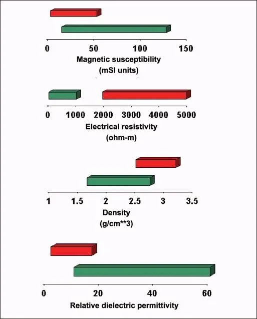
Figure 3. Contrast in physical properties between kimberlites (green) and granitic rocks (red). Most kimberlites located to date intrude into granitic and high-grade metamorphic rocks with similar physical properties.
Geophysical methods have proven to be essential in successful Slave Craton kimberlite exploration programs. Kimberlite intrusions have distinct geophysical signatures controlled by the physical property contrast between the kimberlite and surrounding rock and by the shape and size of the intrusions and their associated anomalies. In addition, kimberlites with very weak geophysical signatures can be discriminated from spurious sources by the location of anomalies in relation to structural features and known kimberlite intrusions. Figure 3 illustrates the physical property contrast between the various kimberlite facies, granitic rocks common in the central Slave Craton and the overlying overburden, common in the central Slave Craton. Contrasts in magnetic suscepti¬bility, electrical resistivity, density, dielectric permittivity and seismic velocity between kim-berlites and their host rocks generate anomalies which, in the case of kimberlite pipes, are fur¬ther enhanced by their distinctive geometry. Crater facies kimberlite generally displays the greatest contrast in physical properties and kimberlite pipes or dykes containing this facies are most readily detectible with geophysical methods. Unfortunately, spurious anomalies can be generated by a wide variety of bedrock and surficial features. In recent years, geophysical programs tend to incorporate a suite of surveys designed to exploit several different physical property contrasts. This approach is particularly necessary in the more heavily explored portions of the Slave Craton.
In general, exploration programs begin with an airborne total magnetic field and electromagnetic (EM) survey of a large area defined by indicator mineral sampling. Follow-up ground surveys are then conducted over a suite of anomalies screened from the airborne survey results. The primary objective of the ground surveys is to fix the location of the airborne magnetic field and/or EM anomalies and to determine if a density, ground radar or seismic velocity anomaly is also present. The most favorable of the ground follow-up targets are then tested by drilling. If diamondif-erous kimberlite is intersected, additional detailed geophysical surveys may be conducted to delineate the intrusion and assist in the definition of phases in the pipe prior to commencing detailed drilling or bulk sampling. In all phases of this work, geophysical interpretation incorporating knowledge of local kimberlite responses and geology is essential.
Magnetics.
Kimberlites are ultramafic rocks with reported susceptibilities in the range of 1 to 80 x 10-3 SI units. In most intrusive settings, there is a positive susceptibility contrast between the kimberlite and the surrounding country rock. In addition, the magnetic responses of many kimberlite intrusions are greatly enhanced by strong remnant magnetism. Kimberlite pipes in a cluster tend to have the same intensity and direction of remnant magnetism but it is also possible to find pipes in close proximity with different magnetic signatures. Spurious anomalies are generated principally in situations where the kimberlites are expressed as weak lows. This occurs immediately north of the Ekati Mine Property where pipes tend to be expressed as smooth 50150 nT lows. Lakes filled with anomalously thick sections of nonmagnetic overburden generate similar magnetic field lows in this area which, when combined with coincident resistivity lows creates numerous false anomalies.
Figure 4 illustrates the range of total magnetic field responses associated with kimberlite pipes in the Slave Craton. We can see the ability of remanent magnetisim to cause a wide range of values in kimberlites. The magnetic moments within magnetic materials, if present in the kimberlite body, align to the local field after the intrusion occurs and remain in that orientation once the kimberlite body cools. The size and shape of the body in addition to these orientated magnetic materials may produce a wide variety of magnetic results. Many kimberlites have been discovered in association with diabase dykes, regional faults and geological contacts and thus regional scale geological structures play an important part in the selection of magnetic targets for investigation. These structures and their intersections produce local areas of weakness in the crust, providing a path of lower resistance for kimberlite intrusions. Intersections of multiple structures are given more weight in the target selection process. It is helpful that in many instances these regional structures can be readily identified using magnetics surveys.
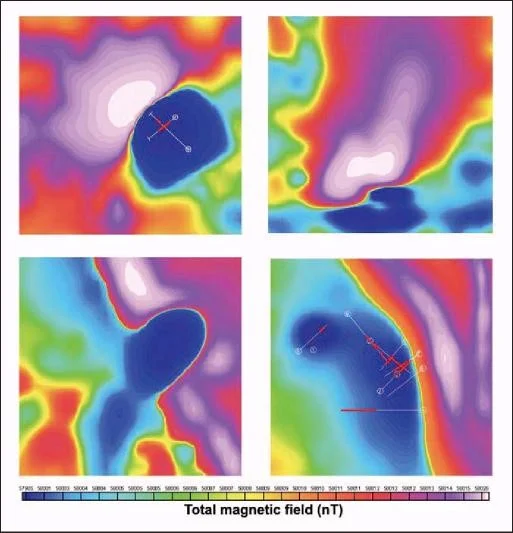
Figure 4. Representative magnetic field responses of kimberlite pipes include (top left) dipole response, (top right) kimberlite as magnetic high, (bottom left) kimberlite as a magnetic low breaking diabase dyke, and (bottom right) magnetic low kimberlite adjacent to diabase dyke.
Electromagnetics.
There is generally a strong contrast in electrical resistivity between kimberlites and surrounding granitic rocks in the Slave Craton. This contrast is most pronounced for crater facies kimberlite and is largely due to serpentinization and clay alteration. Pipes with crater facies kimberlite are generally evident as resistivity lows with apparent resistivities in the range of 1-100 ohm-m. Spurious EM/resistivity anomalies are also generated by a range of surficial and bedrock sources. Lacustrine clays and some glacial deposits have electrical resistivities in the same range as kimberlite; consequently, these sediments are major sources of false anomalies. Similarly, localized zones of argillaceous alteration, particularly at the intersection of faults and along diabase dikes, can generate bedrock resistivity lows with signatures similar to those exhibited by kimberlite pipes.
Multicoil helicopter-borne EM systems and, less fre-quently, fixed-wing time-domain EM systems are used in first-pass surveys for most exploration programs. Ground follow-up surveys usually include horizontal loop EM (HLEM) surveys operating from 220 Hz to 28 KHz at a coil spacing of 100 m. Ground time-domain EM surveys have been used less frequently, principally because of the cost. Coincident loop TDEM data, however, can be inverted to yield some information on the anomaly source geometry using stacked 1D inversions and this information can be useful in discriminating surficial targets from bedrock conductors. In contrast, kimberlite HLEM responses do not lend themselves to unassisted inversion.
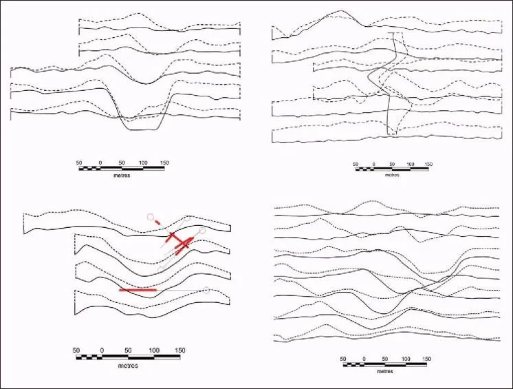
Figure 5. Representative horizontal loop electromagnetic responses of kimberlite pipes. In-phase profiles solid, quadrature dashed. Shown are (top left) crater facies kimberlite, (top right) diatreme facies kimberlite, (bottom left) offset response, and (bottom right) near surface weathered kimberlite.
Figure 5 illustrates typical HLEM responses associated with kimberlite pipes in the Slave Craton. A wide range of responses can occur and can be attributed to the facies that are preserved in the kimberlite. Generally, the crater facies and the upper portions of the diatreme facies are more porous and weathered. These portions of the kimberlite may contain conductive clay particles as well. These facies, if preserved, are relatively electrically conductive and may be visualized with the horizontal loop EM survey.
Kimberlites are generally much softer than the sur-rounding rocks and are thus preferentially scoured by glaciation events. After such events, it is observed that the greatest amount of material is scoured and deposited directly down ice of the kimberlite body. These depressions once filled with sediments and clays will produce an EM response which can be offset down ice. Many ground geophysical surveys over kimberlites have produced magnetic and EM responses which are offset from one another due to these glacial scouring events. For these reasons it is important not to rely solely on one geophysical method. The horizontal loop EM does provide information that, when added to the larger exploration picture, aides in the identification and pri-oritization of kimberlite targets.
A recent innovation has been the introduction of the capacitive coupled resistivity (CCR) method to kimberlite exploration. Originally developed in Russia, and further refined in Canada, this method relies upon capacitive as opposed to galvanic coupling to introduce a relatively high frequency (8 KHz) electric field into the earth. Twenty-meter receiving and transmitting dipole antennas consisting of braided wire are separated at a fixed spacing of 100 m or more and the entire array is dragged along the ground in a manner similar to an HLEM survey. The recorded voltage and fixed current are converted to an apparent resistivity and plotted at the midpoint between the antennas. The depth of investigation is in the order of the antenna separation and the survey results are a useful complement to airborne resistivity results. Figure 6 illustrates the responses of kimberlite pipes both beneath a lake and on land. In both cases, responses from lake bottom sediments are apparent but the kimberlite pipes are nonetheless apparent as clear resistivity lows. It is worth noting that the response over the land-based pipe is significantly stronger than the air-borne resistivity response, a consequence of the antennas on surface providing stronger signal and better coupling with the ground.
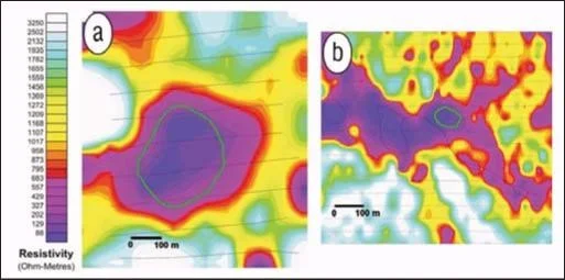
Figure 6. Capacitively-coupled resistivity response of kimberlite pipes at 100 m dipole spacing. Pipe outlines are shown in green. (a) Kimberlite pipe beneath a lake (b) Kimberlite pipe on land. In both cases, conductive lake bottom sediments or overburden overprint the response.
Gravity.
In the Slave Craton, there is a range of density contrasts between kimberlites and surrounding country rocks. The density contrast is most pronounced for both crater and diatreme facies kimberlite where serpentinization and clay alteration are present. Hypabyssal kimberlite has a density range which overlaps that of the surrounding granitic and metasedimentary rocks. Kimberlite pipes containing crater facies will commonly generate obvious Bouguer lows of 0.5 to 1.0 mGal. There are numerous sources of false anomalies including anomalously thick sections of lake-bottom overburden, alteration zones at the intersections of structures and small stocks of low-density felsic igneous rocks within larger granitic intrusions. Gravity surveys are considered a subsidiary complement to magnetic field and EM surveys, given the relatively low-amplitude contrast and the presence of spurious sources. The introduction and successful application of the Falcon airborne gravity gra-diometer system at the Ekati Mine property in the late 1990s spurred the application of this technique elsewhere in the Slave Craton.
Improvements over the past decade in gravity survey techniques have greatly increased field efficiencies, reduced costs and reduced sources of error. These improvements have also enhanced the utility of gravity data in identifying kim-berlite intrusions. The principal innovations have been the introduction of kinematic carrier phase GPS surveys for topographic leveling; the use of accurate digital terrain models in performing terrain corrections; and the employment of improved water depth correction algorithms. The latter is a significant factor given that most kimberlite targets occur beneath or adjacent to small lakes. The application of water corrections based on algorithms developed for use on sea ice or large lakes is completely inappropriate in these situations. Instead, survey crews take soundings at gravity stations on the ice and merge this data with other soundings and the mapped edge of the lakes to create digital bathymetry models. Water depth corrections are then applied by performing a terrain correction using the bathym-etry model as input.
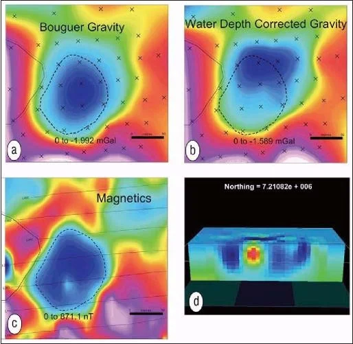
Figure 7. Gravity response of a kimberlite pipe beneath a lake. (a) Bouguer gravity after all conventional corrections. (b) Bouguer gravity after lake water depth correction. (c) Total magnetic field response indicating location of granitic xenolith in southern section of the pipe. (d) 3D gravity model cross-section through small magnetic field high. Inversion of water-depth corrected gravity identifies this feature clearly.
Figure 7 illustrates the gravity response of a kimberlite pipe beneath a lake showing the Bouguer anomaly before and after water column corrections, (a) and (b). Water depth contours are superimposed on both anomalies. The final corrected Bouguer anomaly data indicates that the source center of mass is located north of the deepest point in the lake. At this location, drilling intersected a granite xenolith with surface dimensions of 50 x 50 m which evidently slid into the pipe crater following intrusion. This feature is evident as a subsidiary total magnetic field high (c) immersed within the larger low generated by the kimberlite pipe. Three-dimensional inversion of the gravity data, shown in (d), accurately illustrates both the location and dimensions of the granitic xenolith.
Ground-penetrating radar.
Kimberlite intrusions can be detected by ground-penetrating radar (GPR) surveys as a consequence of the contrast in both dielectric permittivity and electrical resistivity between kimberlites and surrounding rocks. Both serpentinization and clay alteration cause kimberlites to have higher liquid bound water con-centrations than the relatively dry surrounding host rocks. This contrast persists in permafrost conditions because of
the presence of electrolytes in the bound water. Con-sequently, kimberlites have a higher relative dielectric permittivity than host rocks and the contact between the two rock types is a radar reflector.
GPR surveys are most efficiently run during winter months where optimal access maximizes survey efficiency. Helicopter-supported reconnaissance surveys are normally carried out on foot by a two-man crew while detailed surveys can be run with a snow machine to tow the equipment. GPR instruments are not designed for cold weather operation. Consequently, the instruments and operating computer must be shielded in a hot-box and the fiber-optic cables shrouded to prevent shattering.
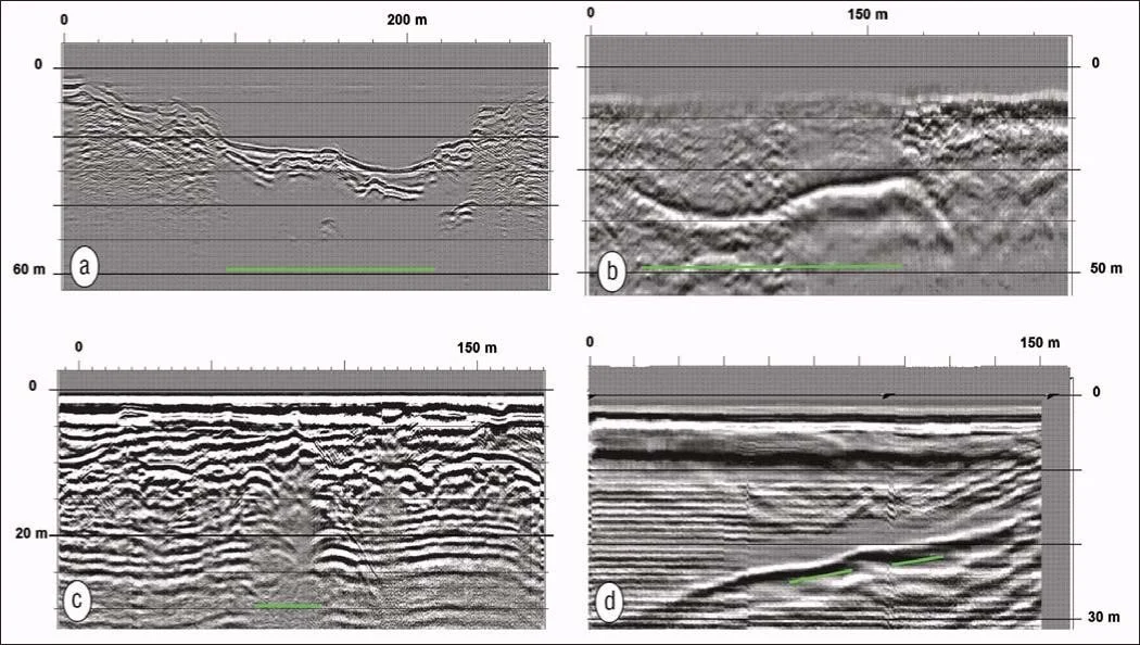
Figure 8. GPR responses of kimberlite pipes and dykes. (a) Response of a kimberlite pipe beneath a lake at 25 MHz. (b) Response of a kimberlite pipe at 12.5 MHz beneath 40 m of overburden. (c) GPR response of a hypabyssal kimberlite dyke intruding bedded limestone at 25 MHz. (d) Response of a shallow dipping dyke at 25 MHz; kimberlite occurs beneath a diabase dyke, the top of which is the strong reflector.
Figure 8 illustrates the GPR response of kimberlite pipes and dykes. Figure 8a displays the response of a kimberlite pipe beneath a lake. The top of the pipe is clearly evident as a smooth planar reflector with evident attenuation. The fractured surrounding granite displays multiple diffraction hyperbolas and trails, generating a contrast in texture. The steep granitic walls of the pipe and the lake bottom sediments are clearly visible in the radargram. The response of a kimberlite pipe on land is shown in Figure 8b. Crater facies kimberlite subcropping at a depth of 38 m beneath boulder till produces a clear strong reflection at a center frequency of 12.5 MHz.
While GPR surveys can image kimberlite pipes to depths in the order of 50 m, the results cannot be used to conclusively identify kimberlite without supporting magnetic, resistivity, or gravity data. There are numerous surficial features including lacustrine clay deposits and rafts of metased-imentary rocks which can produce spurious GPR anomalies. Instead, GPR surveys have proven to be most useful in delineating the extent of a kimberlite pipe following an initial confirmatory drill hole. Radar reflections known to be associated with the pipe can then be mapped to determine the areal extent of the pipe and the depth of overburden.
GPR surveys are proving to be a primary tool in the location of kimberlite dikes however. Moderate-to-steeply dipping kimberlite dikes have very clear GPR responses and GPR surveys have been used to successfully locate dia-mondiferous kimberlite dikes near Kenady Lake, Great Slave Lake, and Victoria Island. In Figure 8c, the 25 MHz response is shown over a 25-m wide vertical dyke intruding Paleozoic limestone. Clear diffractions from the margins of the dyke assist in defining the walls of the intrusion. Figure 8c illustrates the GPR response over a shallow-dipping kimberlite dyke. The dominant reflection is produced by a selvage overlying a precursor diabase dyke; kimberlite up to 1-m thick occurs beneath the diabase. Many areal extensive indicator mineral trains are thought to originate from kimber-lite dykes or sills. In these areas, GPR surveys can be used to identify prospective dykes or sills for drill testing.
Seismic.
Despite the clear contrast in seismic velocity between kimberlites and surrounding country rocks, seismic surveys have not been used extensively in Slave Craton. Seismic refraction surveys have been conducted over sev-eral kimberlite pipes and results suggest that seismic velocity measurements from reversed refraction profiles might be useful screening targets in granitic rocks. Two orthogonal reversed profiles are recommended over a target to mitigate against velocity anisotropy. In metasedimentary rocks, the possibility of velocity overlap suggests that seismic refraction surveys may not provide conclusive results.
High-resolution 2D seismic reflection surveys have been conducted at Snap Lake to delineate a diamondiferous kim-berlite dike hosting reserves of 22.8 million tons at 4.0 ct/t. The survey employed a 1024-channel ARAM system and used vibroseis and dynamite as energy sources. Receivers consisted of single phones at a 4-m spacing and source points were spaced 8 m apart along two lines. Figure 9 illustrates the reflection section recorded over a line, extending northwest and downdip from the surface outcrop of the Snap Lake dyke. The 1-2 m wide dyke is clearly visible as a discrete feature to depths of 1800 m.
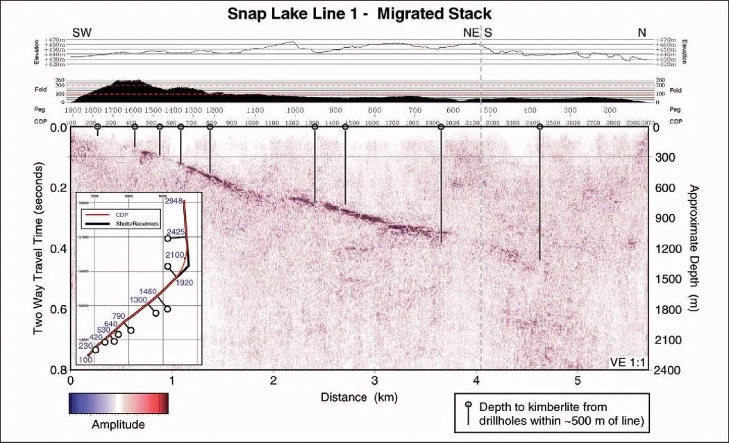
Figure 9. Seismic reflection survey over Snap Lake kimberlite dyke.
Conclusion.
The discovery and rapid development of the diamond mining industry in northern Canada is a direct result of the coordinated application of geophysical and geochemical methods. Magnetic and electromagnetic methods commonly locate the majority of kimberlite intrusions in a new area. Complementary techniques are more commonly used in heavily explored areas to identify kimberlite intrusions with weak magnetic or resistivity responses. Geophysical techniques are also being used to define the geometry of diamondiferous kimberlite intrusions during development drilling. With the development of several long-life diamond mines and the discovery of numerous other potentially economic deposits, there will be a continuing requirement to apply, adapt and improve geophysical methods for kimberlite exploration in northern Canada.
Suggested Reading.
“Geotectonic controls of primary diamond deposits: implications for area selection” by Helmstaedt and Gurney (Journal of Geochemical Exploration, 1995).
“Slave Province Kimberlites, NWT” by Kjarsaard (in Searching for Diamonds in Canada, Geological Survey of Canada Open File 3228, 1996.)
Acknowledgments: The authors thank Aber Resources, Darnley Bay Resources, Diamondex Resources, Diamonds North Resources, Diavik Diamond Mines, Intertech Minerals, and Snowfield Development Corporation and Southern Era Resources for permission to present the data in this paper. The authors gratefully acknowledge help from Anne Hall and Karen Jane Weir (nee Wright) to keep us on the geological straight and narrow and patient assistance in image preparation from Jim Robinson and Holly Stirling.
Related Services

Popular Posts


Categories
Find Us
Yellowknife
3506 McDonald Dr.
Yellowknife, NT
Canada
X1A 2H1
Whitehorse
34A Laberge Rd.
Whitehorse, YT
Canada
Y1A 5Y9
Juneau
Juneau, AK
United States
Message Us
Work
FEATURED CASE STUDIES
-
Aurora Rapid Reactance Tomography (ARRT) - Rapid Electrical Imaging for Mineral Exploration
Jun 22, 2026
-
Operational Trust in the Field - A Case Study at White Cliff Minerals’ Rae Copper Project
Jun 22, 2026
-
GIS - Based Mineral Potential Regional-Scale Study - Slave Geological Province, NWT
Apr 09, 2026