Mapping the Critical Mineral Potential of Canada’s Slave Geological Province
Publication: NWT Open Report 2026-003 (doi.org/10.46887/2026-003)
Overview
The Slave Geological Province in the eastern Northwest Territories is one of Canada’s most mineral-rich geological formations, with a long history of diamond and gold production and broad potential for critical minerals essential to Canada’s energy transition and supply chain security. Aurora Geosciences has been the GNWT’s technical partner on mineral potential mapping in this region since the original 2015 Slave Geological Province Road Corridor Study, followed by a refined assessment in 2019.
In 2025, the GNWT Department of Infrastructure retained Aurora to deliver a comprehensive update with a new strategic focus on critical minerals-reflecting growing global demand. The work was carried out between August and October 2025, with the resulting technical report published as NWT Open Report 2026-003 and announced at PDAC 2026, Canada’s premier mining convention.
Challenge
The GNWT needed to refresh its understanding of mineral potential across the Slave Geological Province with particular emphasis on minerals critical to Canada and their growing demand. Previous assessments, while valuable, were oriented heavily toward diamond exploration. The 2025 update was needed to re-weight the analysis toward critical minerals such as lithium, cobalt, copper, and zinc, incorporate new geological and mineral occurrence data accumulated since 2019, and extend the study area to include the territory of the Tłı̀chǫ Government. The results needed to serve as publicly available planning and investment tools - supporting not only exploration targeting but also downstream spatial analyses for infrastructure development. The mineral potential suitability rasters produced by this study are designed to integrate directly with GIS-based decision-support workflows such as least-cost-path analysis for road and utility corridor routing, weighted overlay modelling for infrastructure siting, and multi-criteria evaluation of competing development scenarios. By delivering scored, weighted, and spatially continuous raster datasets, the study provides planners and analysts with a GIS-ready evidence base that can be combined with other spatial criteria - environmental, geotechnical, socioeconomic - as planning advances for projects like the proposed Arctic Economic and Security Corridor and the Taltson Hydroelectric Expansion.
Approach
Aurora’s team applied a GIS-based multi-criteria analysis following the Analytical Hierarchy Process (AHP) methodology, building on and refining the approach established in the 2015 and 2019 studies. Six factors were evaluated, scored, and weighted through pair-wise comparison by a panel of experienced geoscientists:
Mineral Occurrences (30.09%) - 3,265 occurrences from the NWT Mineral Showings Database and NUMIN databases were systematically scored by development stage and commodity group. The commodity scoring was re-weighted to favour critical minerals: strategic metals (Nb, Ta, REE, U, Th, Li, Be) and base metals (Co, Ni, W, Sn, Zn, Cu, Pb, Mo) scored highest, while diamonds were scored significantly lower than in previous studies. A total of 116 new occurrences not captured in the 2019 study were added, and 17 records had their development stages updated to reflect current project status.
Bedrock Geology (27.86%) - 360 unique bedrock units were identified from an expanded compilation of four geological map datasets, including two additional datasets not used in the 2019 study. Three panellists scored each unit from 0.1 to 99.9 for mineral favourability. Bedrock units hosting Malley dykes received a 10-point score upgrade due to their prospectivity for vanadium, titanium, and associated mineralization.
Geophysical Surveys (25.82%) - Airborne survey coverage was classified into eight categories by method (electromagnetic, gravity, radiometric, magnetic) and resolution (≤4 00 m vs. >400 m line spacing), then scored through pair-wise comparison. This factor increased substantially in importance from 13.06% in the 2019 study to 25.82%, reflecting the value of geophysical data in identifying critical mineral deposit types.
Faults (9.56%), Mineral Tenure (4.34%), and Dykes (2.33%) - Fault and dyke proximity were modelled using Euclidean distance with exponential decay functions. Six mineral tenure types were distinguished and scored, with active and past leases ranked highest as indicators of advanced exploration interest.
All factor datasets were converted to raster format with a 100 m × 100 m cell resolution, standardized to a 1 - 255 value range, and combined as a weighted sum to produce the final mineral potential suitability rasters. A dedicated critical minerals layer was generated using only the subset of 1,721 showings associated with 19 critical minerals. Data confidence layers were also produced, classifying areas by the number of contributing factor datasets with sufficient spatial coverage.
Deliverables
The study produced a suite of publicly available products designed to serve as planning and investment tools for government, industry, and Indigenous decision-makers:
Interpreted Mineral Potential Map - a high-resolution heat map showing the weighted mineral potential across the full study area, driven primarily by the three highest-weighted factors (mineral occurrences, bedrock geology, and geophysical surveys). High-potential areas align strongly with volcanic greenstone belts and clustered mineral occurrences.
Interpreted Critical Mineral Potential Map - derived using only critical-mineral-associated showings, highlighting areas with the strongest potential for lithium, cobalt, copper, zinc, and other minerals on Canada’s critical list. The updated analysis identified significant potential for hard-rock lithium in areas hosting pegmatitic intrusions, and for iron oxide-copper-gold (IOCG) deposits within the Great Bear Magmatic Zone.
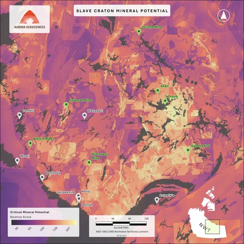
Six thematic factor heat maps - individual layers for mineral occurrences (all and critical-only), bedrock geology, geophysical surveys, mineral tenure, faults, and dykes, each serving as a standalone analytical product.
Data confidence maps - classifying areas as low, medium, or high confidence based on the spatial coverage and resolution of contributing datasets, providing essential context for interpreting the mineral potential estimates.
Comprehensive technical report and digital data - documenting the full methodology, scoring results, and factor layers, accompanied by digital appendices including bedrock unit scores, mineral occurrence scores, factor layer geodatabases, and the data gap analysis.
Impact
The GNWT released the study at PDAC 2026, where it was presented as a key component of the territory’s strategy to attract exploration investment and advance strategic infrastructure. The mineral potential data directly support the business case for the proposed Arctic Economic and Security Corridor and the Taltson Hydroelectric Expansion, two infrastructure projects designed to improve access, energy supply, and economic viability for mineral development across the Slave Geological Province.
By shifting the analytical lens from diamond exploration to critical minerals, the study re-evaluates the region’s resource potential that aligns with current federal and territorial priorities. The publicly available maps and datasets provide exploration companies with lower-risk targeting tools and give government and Indigenous partners a stronger evidence base for land use planning and infrastructure investment decisions.
Related Services


Popular Posts


Categories
Find Us
Yellowknife
3506 McDonald Dr.
Yellowknife, NT
Canada
X1A 2H1
Whitehorse
34A Laberge Rd.
Whitehorse, YT
Canada
Y1A 5Y9
Juneau
Juneau, AK
United States